


1-Voting District, Columbia County, Florida
About
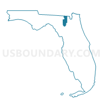
Outline

Summary
| Unique Area Identifier | 552667 |
| Name | 1-Voting District |
| County | Columbia County |
| State | Florida |
| Area (square miles) | 32.30 |
| Land Area (square miles) | 32.27 |
| Water Area (square miles) | 0.03 |
| % of Land Area | 99.90 |
| % of Water Area | 0.10 |
| Latitude of the Internal Point | 30.02982670 |
| Longtitude of the Internal Point | -82.72987930 |
Maps


Graphs
Select a template below for downloading or customizing gragh for 1-Voting District, Columbia County, Florida


Neighbors
Neighoring Voting District (by Name) Neighboring Voting District on the Map
- 13-Voting District, Suwannee County, FL
- 16-Voting District, Suwannee County, FL
- 19-Voting District, Columbia County, FL
- 23-Voting District, Columbia County, FL
- 3-Voting District, Columbia County, FL
- 6-Voting District, Columbia County, FL
Top 10 Neighboring County Subdivision (by Population) Neighboring County Subdivision on the Map
- Lake City CCD, Columbia County, FL (50,281)
- Fort White CCD, Columbia County, FL (15,489)
- McAlpin-Wellborn CCD, Suwannee County, FL (9,116)
- Branford CCD, Suwannee County, FL (6,859)
Top 10 Neighboring Unified School District (by Population) Neighboring Unified School District on the Map
Top 10 Neighboring State Legislative District Lower Chamber (by Population) Neighboring State Legislative District Lower Chamber on the Map
Top 10 Neighboring State Legislative District Upper Chamber (by Population) Neighboring State Legislative District Upper Chamber on the Map
Top 10 Neighboring 111th Congressional District (by Population) Neighboring 111th Congressional District on the Map
Top 10 Neighboring Census Tract (by Population) Neighboring Census Tract on the Map
- Census Tract 9705, Suwannee County, FL (9,116)
- Census Tract 9706, Suwannee County, FL (6,859)
- Census Tract 1109.04, Columbia County, FL (5,828)
- Census Tract 1109.01, Columbia County, FL (5,596)
- Census Tract 1106.02, Columbia County, FL (4,249)